Directions from Huan Chetawan Hotel / Huern Che Ta One Hotel, in Phrae Town, Chetawan Alley, Nai Wiang, Mueang Phrae District, Phrae to Huan Chetawan Hotel / Huern Che Ta One Hotel, in Phrae Town, Chetawan Alley, Nai Wiang, Mueang Phrae District, Phrae_Directions from Huan Chetawan Hotel / Huern Che Ta One Hotel, in Phrae Town, Chetawan Alley, Nai Wiang, Mueang Phrae District, Phrae to Huan Chetawan Hotel / Huern Che Ta One Hotel, in Phrae Town, Chetawan Alley, Nai Wiang, Mueang Phrae District, Phrae
Mae Khon Kaen restaurant

Mae Khon Kaen restaurant
Mae Khon Kaen restaurant
Mae Khon Kaen restaurant
Chetawan Cave Tempel
Chetawan Cave Tempel
Chetawan Cave Tempel
Chetawan Cave Tempel
Wat Bo Kaeo
Wat Bo Kaeo
Pak Nai Car Ferry
Pak Nai Car Ferry
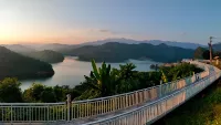
Skywalk Huai Ree Reservoir
Skywalk Huai Ree Reservoir
Skywalk Huai Ree Reservoir
Skywalk Huai Ree Reservoir
Viewpoint Route 1022 / Rural Road 4001
Viewpoint Route 1022 / Rural Road 4001
Monk Klam restaurant and coffee shop
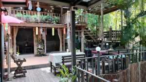
Monk Klam restaurant and coffee shop
Monk Klam restaurant and coffee shop
Monk Klam restaurant and coffee shop
Restaurant & Coffee shop
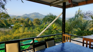
Restaurant & Coffee shop
Restaurant & Coffee shop
Restaurant & Coffee shop
Sunee Boutique Hotel
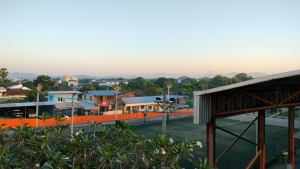
Sunee Boutique Hotel
Huern Che Ta One Hotel
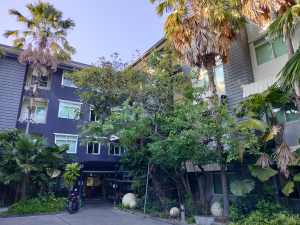
Huern Che Ta One Hotel
Filter Map
Large Phrae Loop
Table of content
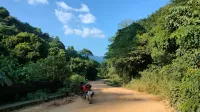
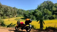
But the elevation change is mild and when the road is not too sandy or too muddy it's not a difficult road to drive on with a heavier street bike. It's an extremely curvy road snaking through thick forested Lam Nam Nan national park. There are just a few villages and no or little visible agriculture. Just green mountains and a twisty dirt road.
The car ferry on the border of Uttaradit and Nan is another 125 kilometers away. The first 75 kilometers with many straight stretches are not the most exciting to drive on. But the surroundings are green, and when you turn onto Route 1339, the road becomes a joy to drive on again, with many turns and some elevation changes.
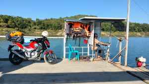
It's a short ferry ride of about a kilometer. The cost of the ticket is 150 THB one way. I tried to figure out when the first and the last ferry leaves, but I wasn't able to. The captain of the ferry was already on his way back when I finished parking my bike, and the restaurant next to where you have to board was empty. There were no people selling tickets that I could ask. I asked the owner of the hotel that I stayed in while I was in Nan, and he thought the ferry left at least till 17.00 o'clock and maybe later.
Short after Wat Bo Kaeo you'll have to turn left onto Route 2051. It's a fun road with curves, some hills and small and relatively remote villages.
The Sunee boutique hotel in Uttaradit is a good budget option. I paid 400 THB through Agoda. The rooms on one side of the Hotel overlooks the parking lot with palm trees and greenery. The other side overlooks a football club and the mountains (if your room is high enough up). The shower had plenty of water pressure and was hot and there is a small balcony. The hotel is situated in a residential neighborhood and away from the big road.
I stayed at the Huern Che Ta One Hotel and there was a sign for a car & motorcycle rental shop called Be Bike Phrae. See my post about Phrae for more info.
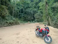
This loop snakes for about 340 kilometers through a beautiful and a desolate part of the Phi Pan Nam mountain range. There is very little traffic on these small mountain roads, except for people living and working in this area. This loop will take you to the scenic Skywalk Huai Ree Reservoir, the beautiful Chetawan Cave Tempel, small villages and breathtaking scenery. Route 1022 is a dirt road for about 40 kilometers, including sections where they have begun to seal the road with concrete slabs. There isn't much elevation change, and when I went there in November, the road was hard and not muddy or overly sandy, and it was perfectly doable on my Honda CB300f with IRC race tires.
I would suggest taking at least two days for this trip, with an overnight stop at one of the places along the way or in Uttaradit, like I did. I stayed at the Sunee Boutique Hotel. See map and further down this page for more info. I recommend taking this route counterclockwise so that you start with the dirt road section of the loop. This minimizes the risk of ending up in the most desolate and challenging part of the loop in the dark. If you want to travel the loop in two or more days, I recommend visiting the Skywalk Huai Ree Reservoir at sunset, when it is at its most stunning. Another factor to consider is the operating hours of the car ferry which you will have to take to cross Sirikit lake (see map for location). I tried to find out the operating hours, but was not able to.
Sights, stops & description of the route
Lam Nam Nan National Park
When entering the mountains, you could opt for a coffee and or food at Monk Klam restaurant and coffee shop (see map - they open at 9.30). They serve a good iced latte for 45 THB and food is between 100 -150 THB. Next, continue and enjoy the many green mountain flanked curves on Route 1022. The first bit of the road is in good condition, but after a little while the road becomes smaller with a lot of sand and other spill over from the verge. In some places, the side of the road was collapsed, presumably by the heavy rains from the weeks before. I'm not sure if you have to pay a fee for Lam Nam Nan National Park when staying on Route 1022. There was an unmanned ticket office along the road and I think an opened barrier, but I'm not sure anymore. There were a lot of construction workers at the park's entrance and nobody asked me to stop, so I decided to drive through.
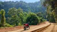
At a certain point, the road becomes a dirt road for about 35 kilometers. Works are in progress to seal the road, but there is still a long way to go. In the beginning, there are concrete slabs to drive on, but after a little while there is only dirt road left.
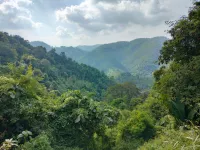
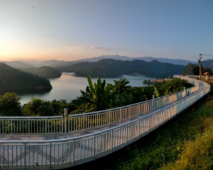
At 17.959654, 100.375187 the road is paved again and what follows is a lovely drive down to Skywalk Huai Ree Reservoir with long curves and magnificent scenery.
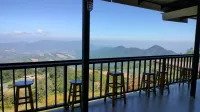
Skywalk Huai Ree Reservoir
This skywalk provides stunning vistas over Huai Ree Reservoir and the surrounding thick green forested mountains. The sunset is particular is breathtaking! There is a coffee shop and a store, but it was closed when I was there.
From here you can choose to overnight in Uttaradit (or somewhere else) or to continue to the car ferry. I stayed in Uttaradit at the Sunee boutique hotel.
Car ferry

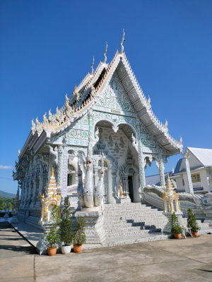
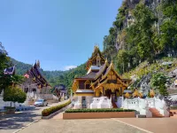
Wat Bo Kaeo
It's a short drive along Route 1026 after exiting the ferry. You'll come across a pretty white temple called Wat Bo Kaeo (see map). It's not a spectacular temple, but it's worth a quick look. Across the street is the last 7-Eleven you'll see before exiting the mountains near Phrae again, but there will be some tiny villages along the way where you can buy the usual items like water and energy drinks.
Route 2051
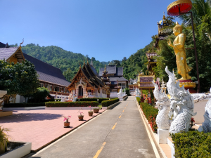
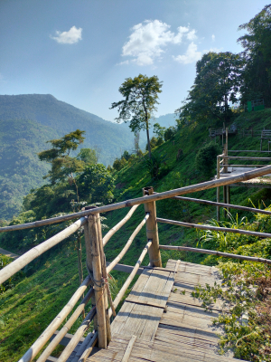
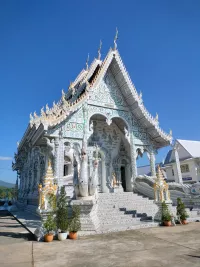
Chetawan Cave Tempel
Route 2051 ends at the impressive and newly build Chetawan Cave Tempel. The temple is surrounded by green thick forested mountains and is flanked by a steep and barren rock face on the right. The compound is quite extensive, with numerous structures, statues, and stairs leading up the mountains, offering breathtaking views and access to two caves. The temple is relatively isolated from more populated regions, and when I was there, there were just a few other people, and I was mostly alone.
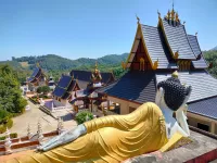
In the back close to the reclining Buddha on the right hand side is a naga staircase which leads up to a small cave and continues along a stupa and some smaller statues. At the end of the stairs is an area with a golden rock with a stuppa on top, which provides a lovely view over the temple grounds.
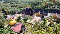
At the front of the temple are more stairs climbing up to another golden rock with a stuppa on top and a larger cave. Unfortunately I couldn't enter because the fence was closed but through the fence I could see that the floor inside the cave was paved and held several structures and statues.
If you turn right after visiting Wat Chetawan Temple (rather than left to continue the route), you'll arrive at Ban Chetawan, a small village with a store and a place to eat. If you have time and want to stop for food and a drink, the surrounding mountains are quite picturesque!
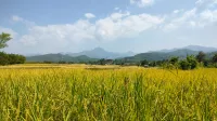
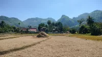
Khun Sathan National Park
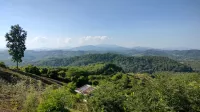
The last odd 45 kilometers before being spat out at Highway 101 are along Route 1216. It's a wonderful small curvy road with minimal traffic aside from those living and working in the area. The road winds past Khun Sathan National Park, forested mountains, and farming fields. There are several coffee shops, but not all of them appeared to be operational when I visited. I had a tasty latte that came with wonderful views at Mae Khon Kaen restaurant (see map for location).
Worth mentioning is that you don't need to pay a National Park fee when driving on route 1216. When you reach Highway 101 you're close to Tham Pha Nang Khoi. It's a lovely cave with colorful lights and is free to enter. See my post about Phrae for details.
Accommodation
Uttaradit: Sunee Boutique Hotel

Phrae: Huan Chetawan Hotel

Huern Che Ta One Hotel in Phrae is excellent value for money! I paid 400 THB via Agoda. Large rooms, firm yet soft mattress (for Thai standards), refrigerator, private parking, air conditioning, kettle, large closet, hot shower with excellent pressure, and complimentary snack and instant coffee in the lobby for breakfast. The hotel is located in a residential area away from busy highways and noise.
Comments