Directions from Wang Noi Guest House, 105, Mae Sariang, Mae Sariang District, Mae Hong Son to Rural Rd Mae Hong Son 3004, Tambon Mae Sam Laep, Amphoe Sop Moei, Chang Wat Mae Hong Son 58110, Thailand
Mae Sam Laep border
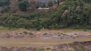
Mae Sam Laep border
Phra That Mae Sam Laep Viewpoint

Phra That Mae Sam Laep Viewpoint
Phra That Mae Sam Laep Viewpoint
Phra That Mae Sam Laep Viewpoint
Filter Map
Things to do in Mae Sariang; Mae Sam Laep Border Tour
Table of content
Sights, stops & description of the route
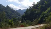
If you love to drive your motorcycle down winding jungle-clad mountain roads, this day trip from Mae Sariang is not to be missed. The road hugs Salawin National Park on one side and is equally mountainous green and lush on the other. Every turn on the 45-kilometer stretch that runs along Salawin National Park is followed by another. You'll pass through villages with bamboo and wooden houses. And, at higher spots along the road, you'll be rewarded with breathtaking views of Salawin National Park's jungle-clad mountains. Take a left just before reaching the Salawin River to reach Phra That Mae Sam Laep Viewpoint. Taking a right across the bridge will bring you to the Mae Sam Laep border (see map further down on this page).
Mae Sam Laep border
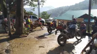
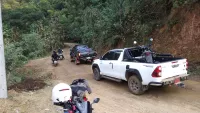
I doubt that many foreign tourists visit here. Although it's difficult to say because at the time of writing Thailand was only accessible through the COVID sandbox scheme and thus had a limited number of foreign travelers and tourists. Also, the boat trips along the Salawin River were halted. The Karen National Union (KNU) seized a military base on the Myanmar side, resulting in bombings and shootings by the Myanmar military. But, the area appears to be popular with Thai campers and off-road motorcyclists. At the border town of Mae Sam Leap I met two groups from Bangkok who were exploring the mountainous dirt roads on their motorcycles from their base in Mae Sariang.
The border town of Mae Sam Laep is an interesting place to visit. The town has a tourist information center as well as a few basic restaurants and shops. There is also a boat service center where you can organize boat trips down the river. However, I doubt it was operational when I visited. The KNU recently seized control of the area across the border. I guess they put up the "Welcome to Kawthoolei". In Karen, Kawthoolei means "Land without darkness," and it is the name given to the land where they want to establish their own independent state. In Mae Sam Leap, I met a former Karen refugee who had returned from the United States to see his family, and he told me that snipers from the Myanmar army would occasionally shoot people trying to cross the river.
Phra That Mae Sam Laep Viewpoint
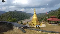
A stupa on the side of Mae Sam Leap offers beautiful views of the Salawin River and the surrounding jungle-clad mountains. The final stretch of road is not visible on Google Maps, so check out the map on this page. You should stay on the 1194 until you come to a sharp left turn going up. This is the path that leads to the Phra That Mae Sam Laep Viewpoint. At the time of writing, there was a blue sign in Thai with white letters and an arrow pointing up to the stupa. You can also use navigation which uses OpenStreetMaps, such as MapsMe.
Practicalities
Road condition
And, just outside town, where the sealed road went over into a dirt track, I saw many 4WDs loaded with camping gear. There were also some campers riding a 125cc semi-automatic motorcycle. The campers most likely came from the Glacier View Point, which is 18 kilometers from Mae Sam Leap and a popular spot to camp.
Unfortunately, the steep muddy dirt roads are inaccessible on my Honda CB with it's IRC S99 sport tires. But combining this tour with the Glacier View Point and Pha Tang Mountain Viewpoint would be phenomenal! I briefly considered renting a Honda Wave to go on a tour from Mae Sariang through Mae Seam Leap, the Glacier View Point, Pha Tang Mountain Viewpoint and Ban Khuay Kong Mool Viewpoint. But I decided to postpone this adventure until another time. It might not be possible to rent one in Mae Sariang and the rain had turned the dry, powdery, steep dirt roads into a mudslide. One of the Bangkok bikers, riding a Yamaha Tenere 700 fell three times, before arriving at Mae Seam Leap.
A word of warning: Highway 1194 along Salawin National Park was in poor condition. It had rained heavily the night before, as well as during the ride. So the conditions may be better (or worse) depending on the weather. There was a lot of sand and small stones in the corners. Some potholes here and there, and in some places the concrete was so damaged for a few meters that it looked more like a dirt road than a sealed one. In several places landslides covered one full lane. In other places big parts of the road had collapsed. That being said, it's not a difficult road to ride. The changes in elevation are moderate. Just keep your speed down, be aware of the things I just mentioned, and enjoy the twists and breathtaking scenery!
Accommodation
Wang Noi Guesthouse
I recommend staying in Mae Sariang. If you look for a budget private room with a hot shower and don't mind sleeping on a hard bed I recommend Wang Noi Guesthouse.
Comments